


Brévent par Planpraz

geoffrayLayeux
User
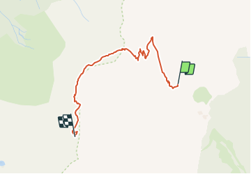

Length
2.7 km

Max alt
2493 m

Uphill gradient
454 m
Km-Effort
7.3 km

Min alt
2061 m

Downhill gradient
24 m
Boucle
No
Creation date :
2021-06-24 16:04:36.104
Updated on :
2021-06-24 16:04:48.513
1h40
Difficulty : Medium

FREE GPS app for hiking
 SityTrail
IGN / Geographical institutes
SityTrail Plus
The world is yours!
About
Trail Walking of 2.7 km to be discovered at Auvergne-Rhône-Alpes, Upper Savoy, Chamonix-Mont-Blanc. This trail is proposed by geoffrayLayeux.
Positioning
Country:
France
Region :
Auvergne-Rhône-Alpes
Department/Province :
Upper Savoy
Municipality :
Chamonix-Mont-Blanc
Location:
Unknown
Start:(Dec)
Start:(UTM)
333323 ; 5089451 (32T) N.
Comments