


Col de Bussang - Chemin des Ormes - Col des Allemands - Chalet St Hubert et retour par GR 531

patrickbeyrath
User
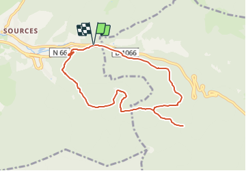

Length
8.2 km

Max alt
933 m

Uphill gradient
342 m
Km-Effort
12.8 km

Min alt
719 m

Downhill gradient
339 m
Boucle
Yes
Creation date :
2021-06-25 15:14:30.427
Updated on :
2021-06-25 15:26:29.841
2h58
Difficulty : Medium

FREE GPS app for hiking
 SityTrail
IGN / Geographical institutes
SityTrail Plus
The world is yours!
About
Trail On foot of 8.2 km to be discovered at Grand Est, Vosges, Bussang. This trail is proposed by patrickbeyrath.
Positioning
Country:
France
Region :
Grand Est
Department/Province :
Vosges
Municipality :
Bussang
Location:
Unknown
Start:(Dec)
Start:(UTM)
342647 ; 5306183 (32T) N.
Comments