


Lac des Bèches

geoffrayLayeux
User
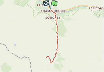

Length
15.2 km

Max alt
2408 m

Uphill gradient
1144 m
Km-Effort
30 km

Min alt
1429 m

Downhill gradient
1144 m
Boucle
Yes
Creation date :
2021-06-26 12:18:35.19
Updated on :
2021-06-26 12:19:02.637
6h54
Difficulty : Very difficult

FREE GPS app for hiking
 SityTrail
IGN / Geographical institutes
SityTrail Plus
The world is yours!
About
Trail Walking of 15.2 km to be discovered at Auvergne-Rhône-Alpes, Isère, Saint-Christophe-en-Oisans. This trail is proposed by geoffrayLayeux.
Positioning
Country:
France
Region :
Auvergne-Rhône-Alpes
Department/Province :
Isère
Municipality :
Saint-Christophe-en-Oisans
Location:
Unknown
Start:(Dec)
Start:(UTM)
279056 ; 4979604 (32T) N.
Comments