


Miroir des Fétoules/table d'orientetion

geoffrayLayeux
User
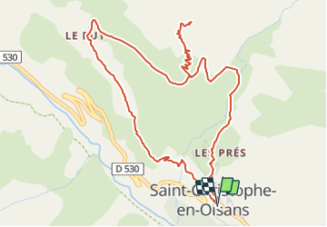

Length
6.7 km

Max alt
2030 m

Uphill gradient
572 m
Km-Effort
14.3 km

Min alt
1464 m

Downhill gradient
574 m
Boucle
Yes
Creation date :
2021-06-26 13:12:36.443
Updated on :
2021-06-26 13:13:24.76
3h15
Difficulty : Difficult

FREE GPS app for hiking
 SityTrail
IGN / Geographical institutes
SityTrail Plus
The world is yours!
About
Trail Walking of 6.7 km to be discovered at Auvergne-Rhône-Alpes, Isère, Saint-Christophe-en-Oisans. This trail is proposed by geoffrayLayeux.
Positioning
Country:
France
Region :
Auvergne-Rhône-Alpes
Department/Province :
Isère
Municipality :
Saint-Christophe-en-Oisans
Location:
Unknown
Start:(Dec)
Start:(UTM)
277324 ; 4982073 (32T) N.
Comments