


La Gouille - Lac Bleu

denissculier
User
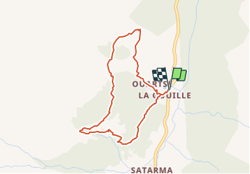

Length
3.8 km

Max alt
2125 m

Uphill gradient
290 m
Km-Effort
7.7 km

Min alt
1830 m

Downhill gradient
290 m
Boucle
Yes
Creation date :
2021-06-26 14:12:46.363
Updated on :
2021-06-26 14:33:45.468
1h43
Difficulty : Medium

FREE GPS app for hiking
 SityTrail
IGN / Geographical institutes
SityTrail Plus
The world is yours!
About
Trail Nordic walking of 3.8 km to be discovered at Valais/Wallis, Hérens, Evolène. This trail is proposed by denissculier.
Positioning
Country:
Switzerland
Region :
Valais/Wallis
Department/Province :
Hérens
Municipality :
Evolène
Location:
Unknown
Start:(Dec)
Start:(UTM)
383218 ; 5101159 (32T) N.
Comments