


SERICHAMPS

surceneux
User
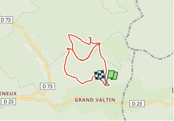

Length
7.7 km

Max alt
1126 m

Uphill gradient
347 m
Km-Effort
12.3 km

Min alt
894 m

Downhill gradient
345 m
Boucle
Yes
Creation date :
2021-06-26 12:26:03.746
Updated on :
2021-06-26 16:55:31.747
2h00
Difficulty : Easy

FREE GPS app for hiking
 SityTrail
IGN / Geographical institutes
SityTrail Plus
The world is yours!
About
Trail Walking of 7.7 km to be discovered at Grand Est, Vosges, Ban-sur-Meurthe-Clefcy. This trail is proposed by surceneux.
Description
BOUCLE ANNEAU BLEU TRIANGLE ROUGE (GRD BOROGE) BOUCLE AUTOUR TETE DES PORCS RETOUR TRIANGLE JAUNE
Positioning
Country:
France
Region :
Grand Est
Department/Province :
Vosges
Municipality :
Ban-sur-Meurthe-Clefcy
Location:
Unknown
Start:(Dec)
Start:(UTM)
350733 ; 5329291 (32U) N.
Comments