


Belmont depuis franchevelle... variante

PatriceCocuaud
User
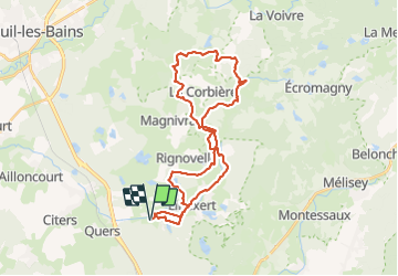

Length
32 km

Max alt
452 m

Uphill gradient
485 m
Km-Effort
39 km

Min alt
296 m

Downhill gradient
484 m
Boucle
Yes
Creation date :
2021-06-27 07:14:12.479
Updated on :
2021-06-27 10:54:33.663
3h39
Difficulty : Medium

FREE GPS app for hiking
 SityTrail
IGN / Geographical institutes
SityTrail Plus
The world is yours!
About
Trail Mountain bike of 32 km to be discovered at Bourgogne-Franche-Comté, Haute-Saône, Franchevelle. This trail is proposed by PatriceCocuaud.
Positioning
Country:
France
Region :
Bourgogne-Franche-Comté
Department/Province :
Haute-Saône
Municipality :
Franchevelle
Location:
Unknown
Start:(Dec)
Start:(UTM)
309561 ; 5290289 (32T) N.
Comments