


Sources de l’Huveaunes

Arnaud Stévenard
User
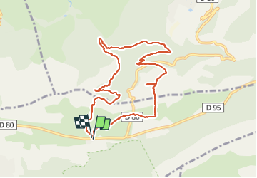

Length
10.4 km

Max alt
708 m

Uphill gradient
383 m
Km-Effort
15.5 km

Min alt
428 m

Downhill gradient
385 m
Boucle
Yes
Creation date :
2021-06-27 07:28:00.0
Updated on :
2021-06-27 12:17:53.627
4h47
Difficulty : Easy

FREE GPS app for hiking
 SityTrail
IGN / Geographical institutes
SityTrail Plus
The world is yours!
About
Trail Walking of 10.4 km to be discovered at Provence-Alpes-Côte d'Azur, Var, Plan-d'Aups-Sainte-Baume. This trail is proposed by Arnaud Stévenard.
Positioning
Country:
France
Region :
Provence-Alpes-Côte d'Azur
Department/Province :
Var
Municipality :
Plan-d'Aups-Sainte-Baume
Location:
Unknown
Start:(Dec)
Start:(UTM)
723551 ; 4801766 (31T) N.
Comments