


cret midi.ban rouge.2021.06.27

trusgnachjf
User
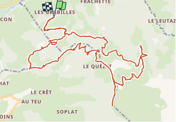

Length
18.8 km

Max alt
1977 m

Uphill gradient
1076 m
Km-Effort
33 km

Min alt
1190 m

Downhill gradient
1072 m
Boucle
Yes
Creation date :
2021-06-27 07:35:03.461
Updated on :
2021-06-27 15:28:55.174
7h51
Difficulty : Very easy

FREE GPS app for hiking
 SityTrail
IGN / Geographical institutes
SityTrail Plus
The world is yours!
About
Trail Walking of 18.8 km to be discovered at Auvergne-Rhône-Alpes, Upper Savoy, Praz-sur-Arly. This trail is proposed by trusgnachjf.
Positioning
Country:
France
Region :
Auvergne-Rhône-Alpes
Department/Province :
Upper Savoy
Municipality :
Praz-sur-Arly
Location:
Unknown
Start:(Dec)
Start:(UTM)
310659 ; 5077490 (32T) N.
Comments