


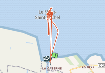
Le Mont St Michel

GOHIER
User

Length
10.1 km

Max alt
57 m

Uphill gradient
243 m
Km-Effort
13.3 km

Min alt
0 m

Downhill gradient
240 m
Boucle
Yes
Creation date :
2021-06-27 08:46:56.0
Updated on :
2021-06-27 16:01:36.449
4h45
Difficulty : Medium

FREE GPS app for hiking
 SityTrail
IGN / Geographical institutes
SityTrail Plus
The world is yours!
About
Trail Walking of 10.1 km to be discovered at Normandy, Manche, Pontorson. This trail is proposed by GOHIER.
Description
Abbatiale fantastique
Positioning
Country:
France
Region :
Normandy
Department/Province :
Manche
Municipality :
Pontorson
Location:
Pontorson
Start:(Dec)
Start:(UTM)
609769 ; 5385985 (30U) N.
Comments