


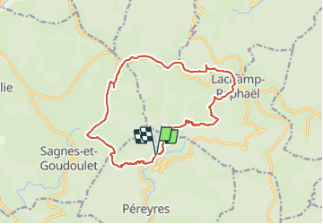
Pont du Ray Pic - Lachamp Raphaël - Sagne Goudoulet

Lustou
User

Length
18.2 km

Max alt
1426 m

Uphill gradient
689 m
Km-Effort
27 km

Min alt
922 m

Downhill gradient
691 m
Boucle
Yes
Creation date :
2021-06-28 07:10:56.0
Updated on :
2021-06-28 19:23:00.625
6h13
Difficulty : Very difficult

FREE GPS app for hiking
 SityTrail
IGN / Geographical institutes
SityTrail Plus
The world is yours!
About
Trail Walking of 18.2 km to be discovered at Auvergne-Rhône-Alpes, Ardèche, Péreyres. This trail is proposed by Lustou.
Description
Rando du 28/06/2021
Eviter le tracé entre La Fialouse et Miralier: pas de sentier

Positioning
Country:
France
Region :
Auvergne-Rhône-Alpes
Department/Province :
Ardèche
Municipality :
Péreyres
Location:
Unknown
Start:(Dec)
Start:(UTM)
599560 ; 4960494 (31T) N.
Comments