


Saint Gervais Saint nazaire

BELLETGE
User

Length
62 km

Max alt
371 m

Uphill gradient
839 m
Km-Effort
73 km

Min alt
168 m

Downhill gradient
839 m
Boucle
Yes
Creation date :
2021-06-25 06:23:35.293
Updated on :
2021-06-29 16:09:18.842
3h17
Difficulty : Easy

FREE GPS app for hiking
 SityTrail
IGN / Geographical institutes
SityTrail Plus
The world is yours!
About
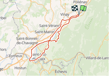
Trail Road bike of 62 km to be discovered at Auvergne-Rhône-Alpes, Isère, Saint-Gervais. This trail is proposed by BELLETGE.
Positioning
Country:
France
Region :
Auvergne-Rhône-Alpes
Department/Province :
Isère
Municipality :
Saint-Gervais
Location:
Unknown
Start:(Dec)
Start:(UTM)
693738 ; 5008938 (31T) N.
Comments