


succieu quinsoas

m261212
User
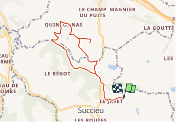

Length
8.7 km

Max alt
461 m

Uphill gradient
191 m
Km-Effort
11.2 km

Min alt
359 m

Downhill gradient
190 m
Boucle
Yes
Creation date :
2021-06-30 12:36:56.403
Updated on :
2021-06-30 12:37:14.512
2h33
Difficulty : Medium

FREE GPS app for hiking
 SityTrail
IGN / Geographical institutes
SityTrail Plus
The world is yours!
About
Trail Walking of 8.7 km to be discovered at Auvergne-Rhône-Alpes, Isère, Succieu. This trail is proposed by m261212.
Positioning
Country:
France
Region :
Auvergne-Rhône-Alpes
Department/Province :
Isère
Municipality :
Succieu
Location:
Unknown
Start:(Dec)
Start:(UTM)
683548 ; 5044562 (31T) N.
Comments