VIRE BOURNE

nordan
User
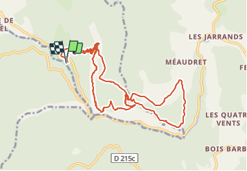

Length
13.2 km

Max alt
1196 m

Uphill gradient
951 m
Km-Effort
26 km

Min alt
676 m

Downhill gradient
951 m
Boucle
Yes
Creation date :
2021-06-30 07:48:21.561
Updated on :
2021-06-30 15:01:52.83
7h04
Difficulty : Difficult

FREE GPS app for hiking
 SityTrail
IGN / Geographical institutes
SityTrail Plus
The world is yours!
About
Trail Walking of 13.2 km to be discovered at Auvergne-Rhône-Alpes, Isère, Rencurel. This trail is proposed by nordan.
Positioning
Country:
France
Region :
Auvergne-Rhône-Alpes
Department/Province :
Isère
Municipality :
Rencurel
Location:
Unknown
Start:(Dec)
Start:(UTM)
695749 ; 4994966 (31T) N.
Comments