


400ème Aller vers la Tuèterie des 8 km

VANDERPUTTENMi
User GUIDE

Length
7.8 km

Max alt
153 m

Uphill gradient
132 m
Km-Effort
9.2 km

Min alt
54 m

Downhill gradient
44 m
Boucle
No
Creation date :
2021-07-03 07:13:38.253
Updated on :
2021-07-03 14:38:21.778
2h28
Difficulty : Medium

FREE GPS app for hiking
 SityTrail
IGN / Geographical institutes
SityTrail Plus
The world is yours!
About
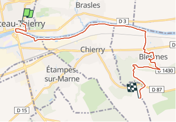
Trail Walking of 7.8 km to be discovered at Hauts-de-France, Aisne, Château-Thierry. This trail is proposed by VANDERPUTTENMi.
Photos

Positioning
Country:
France
Region :
Hauts-de-France
Department/Province :
Aisne
Municipality :
Château-Thierry
Location:
Unknown
Start:(Dec)
Start:(UTM)
529622 ; 5432603 (31U) N.
Comments