


Romme3

raymondfn
User
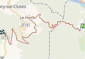

Length
6 km

Max alt
1259 m

Uphill gradient
744 m
Km-Effort
13.4 km

Min alt
510 m

Downhill gradient
0 m
Boucle
No
Creation date :
2021-07-03 08:49:04.0
Updated on :
2021-07-03 11:18:29.348
2h30
Difficulty : Difficult

FREE GPS app for hiking
 SityTrail
IGN / Geographical institutes
SityTrail Plus
The world is yours!
About
Trail Walking of 6 km to be discovered at Auvergne-Rhône-Alpes, Upper Savoy, Magland. This trail is proposed by raymondfn.
Positioning
Country:
France
Region :
Auvergne-Rhône-Alpes
Department/Province :
Upper Savoy
Municipality :
Magland
Location:
Unknown
Start:(Dec)
Start:(UTM)
314553 ; 5100956 (32T) N.
Comments