


le 9 05 2021

gillescailloz
User
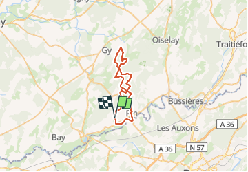

Length
36 km

Max alt
365 m

Uphill gradient
636 m
Km-Effort
45 km

Min alt
203 m

Downhill gradient
637 m
Boucle
Yes
Creation date :
2021-05-09 05:56:25.738
Updated on :
2021-07-04 06:00:02.029
3h19
Difficulty : Difficult

FREE GPS app for hiking
 SityTrail
IGN / Geographical institutes
SityTrail Plus
The world is yours!
About
Trail Mountain bike of 36 km to be discovered at Bourgogne-Franche-Comté, Haute-Saône, Beaumotte-lès-Pin. This trail is proposed by gillescailloz.
Positioning
Country:
France
Region :
Bourgogne-Franche-Comté
Department/Province :
Haute-Saône
Municipality :
Beaumotte-lès-Pin
Location:
Unknown
Start:(Dec)
Start:(UTM)
714072 ; 5244035 (31T) N.
Comments