


Bono sud

Lobin
User
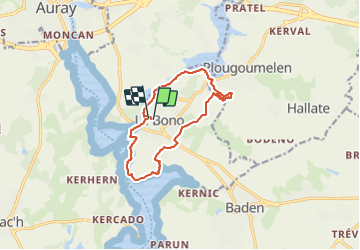

Length
12 km

Max alt
27 m

Uphill gradient
122 m
Km-Effort
13.7 km

Min alt
0 m

Downhill gradient
128 m
Boucle
Yes
Creation date :
2021-07-03 08:57:36.0
Updated on :
2021-07-04 06:52:46.193
21h36
Difficulty : Easy

FREE GPS app for hiking
 SityTrail
IGN / Geographical institutes
SityTrail Plus
The world is yours!
About
Trail Walking of 12 km to be discovered at Brittany, Morbihan, Le Bono. This trail is proposed by Lobin.
Description
Magnifique randonnée en bord de côte et chemin de campagne
Photos

Positioning
Country:
France
Region :
Brittany
Department/Province :
Morbihan
Municipality :
Le Bono
Location:
Unknown
Start:(Dec)
Start:(UTM)
503759 ; 5276318 (30T) N.
Comments