


Tour du mont razet

Arnaud Stévenard
User
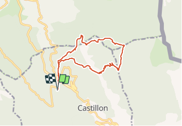

Length
8.4 km

Max alt
1176 m

Uphill gradient
528 m
Km-Effort
15.4 km

Min alt
719 m

Downhill gradient
530 m
Boucle
Yes
Creation date :
2021-07-04 06:06:56.0
Updated on :
2021-07-04 10:48:39.158
4h40
Difficulty : Very easy

FREE GPS app for hiking
 SityTrail
IGN / Geographical institutes
SityTrail Plus
The world is yours!
About
Trail Walking of 8.4 km to be discovered at Provence-Alpes-Côte d'Azur, Maritime Alps, Castillon. This trail is proposed by Arnaud Stévenard.
Positioning
Country:
France
Region :
Provence-Alpes-Côte d'Azur
Department/Province :
Maritime Alps
Municipality :
Castillon
Location:
Unknown
Start:(Dec)
Start:(UTM)
376216 ; 4854975 (32T) N.
Comments