


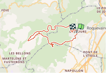
pic de taoune , et le garlaban depart roquevaire

gerardmicheline
User

Length
16.3 km

Max alt
692 m

Uphill gradient
856 m
Km-Effort
28 km

Min alt
202 m

Downhill gradient
859 m
Boucle
Yes
Creation date :
2021-07-04 16:56:53.319
Updated on :
2021-07-04 16:58:38.341
6h17
Difficulty : Very difficult

FREE GPS app for hiking
 SityTrail
IGN / Geographical institutes
SityTrail Plus
The world is yours!
About
Trail Walking of 16.3 km to be discovered at Provence-Alpes-Côte d'Azur, Bouches-du-Rhône, Roquevaire. This trail is proposed by gerardmicheline.
Description
parking rue martoumeu
Positioning
Country:
France
Region :
Provence-Alpes-Côte d'Azur
Department/Province :
Bouches-du-Rhône
Municipality :
Roquevaire
Location:
Unknown
Start:(Dec)
Start:(UTM)
709206 ; 4802365 (31T) N.
Comments