


La Reine des Eaux

denissculier
User
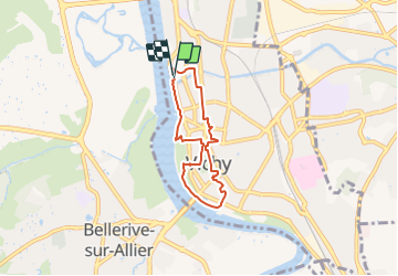

Length
5.3 km

Max alt
269 m

Uphill gradient
43 m
Km-Effort
5.9 km

Min alt
251 m

Downhill gradient
41 m
Boucle
Yes
Creation date :
2021-07-05 12:06:40.199
Updated on :
2021-07-05 12:31:54.901
1h19
Difficulty : Easy

FREE GPS app for hiking
 SityTrail
IGN / Geographical institutes
SityTrail Plus
The world is yours!
About
Trail Nordic walking of 5.3 km to be discovered at Auvergne-Rhône-Alpes, Allier, Vichy. This trail is proposed by denissculier.
Positioning
Country:
France
Region :
Auvergne-Rhône-Alpes
Department/Province :
Allier
Municipality :
Vichy
Location:
Unknown
Start:(Dec)
Start:(UTM)
532058 ; 5108919 (31T) N.
Comments