


Mourre Negre

mhetpierre
User
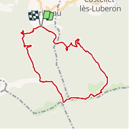

Length
11.5 km

Max alt
1122 m

Uphill gradient
597 m
Km-Effort
19.4 km

Min alt
588 m

Downhill gradient
591 m
Boucle
Yes
Creation date :
2018-08-18 15:31:09.581
Updated on :
2018-08-18 15:31:09.581
5h50
Difficulty : Medium

FREE GPS app for hiking
 SityTrail
IGN / Geographical institutes
SityTrail Plus
The world is yours!
About
Trail Walking of 11.5 km to be discovered at Provence-Alpes-Côte d'Azur, Vaucluse, Auribeau. This trail is proposed by mhetpierre.
Positioning
Country:
France
Region :
Provence-Alpes-Côte d'Azur
Department/Province :
Vaucluse
Municipality :
Auribeau
Location:
Unknown
Start:(Dec)
Start:(UTM)
697621 ; 4856262 (31T) N.
Comments