


Vers le Cinquet avec Sabine

mitch1952
User
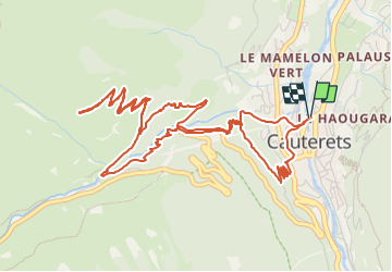

Length
8.2 km

Max alt
1492 m

Uphill gradient
602 m
Km-Effort
16.2 km

Min alt
915 m

Downhill gradient
602 m
Boucle
Yes
Creation date :
2021-07-05 17:28:24.414
Updated on :
2022-06-08 14:07:54.106
3h40
Difficulty : Difficult

FREE GPS app for hiking
 SityTrail
IGN / Geographical institutes
SityTrail Plus
The world is yours!
About
Trail Walking of 8.2 km to be discovered at Occitania, Hautespyrenees, Cauterets. This trail is proposed by mitch1952.
Description
Randonnée effectuée le 5 juillet 2021
Positioning
Country:
France
Region :
Occitania
Department/Province :
Hautespyrenees
Municipality :
Cauterets
Location:
Unknown
Start:(Dec)
Start:(UTM)
735624 ; 4752722 (30T) N.
Comments