


2021-07-05_20h10m00_gpx-file (1)

mumu.larandonneuse
User GUIDE
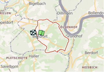

Length
10.6 km

Max alt
394 m

Uphill gradient
227 m
Km-Effort
13.6 km

Min alt
253 m

Downhill gradient
218 m
Boucle
Yes
Creation date :
2021-07-05 18:10:00.224
Updated on :
2023-06-10 17:05:53.424
3h05
Difficulty : Medium

FREE GPS app for hiking
 SityTrail
IGN / Geographical institutes
SityTrail Plus
The world is yours!
About
Trail Walking of 10.6 km to be discovered at Unknown, Canton Echternach, Beaufort. This trail is proposed by mumu.larandonneuse.
Description
📌 château de Beaufort ou directement du Camping Park Beaufort
Balisage en vert sur fond blanc.
Photos
 - Photo 1")
 - Photo 2")
 - Photo 3")
 - Photo 4")
 - Photo 5")
 - Photo 6")
 - Photo 7")
 - Photo 8")
Positioning
Country:
Luxembourg
Region :
Unknown
Department/Province :
Canton Echternach
Municipality :
Beaufort
Location:
Unknown
Start:(Dec)
Start:(UTM)
304894 ; 5523576 (32U) N.
Comments
Superbe parcours varié ... le long des formations rocheuses et le long des ruisseaux pittoresques.