


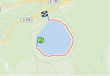
lac pavis

Pachinou
User

Length
2.1 km

Max alt
1249 m

Uphill gradient
68 m
Km-Effort
3 km

Min alt
1203 m

Downhill gradient
82 m
Boucle
No
Creation date :
2021-07-06 08:50:52.784
Updated on :
2021-07-06 09:36:21.309
39m
Difficulty : Easy

FREE GPS app for hiking
 SityTrail
IGN / Geographical institutes
SityTrail Plus
The world is yours!
About
Trail Walking of 2.1 km to be discovered at Auvergne-Rhône-Alpes, Puy-de-Dôme, Besse-et-Saint-Anastaise. This trail is proposed by Pachinou.
Positioning
Country:
France
Region :
Auvergne-Rhône-Alpes
Department/Province :
Puy-de-Dôme
Municipality :
Besse-et-Saint-Anastaise
Location:
Besse
Start:(Dec)
Start:(UTM)
490871 ; 5037858 (31T) N.
Comments