


Stenay

LauVan
User
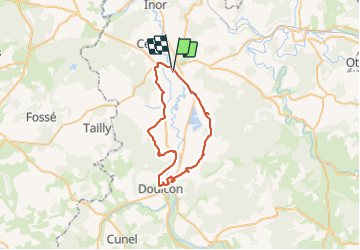

Length
42 km

Max alt
244 m

Uphill gradient
374 m
Km-Effort
47 km

Min alt
162 m

Downhill gradient
377 m
Boucle
No
Creation date :
2021-07-06 09:37:51.655
Updated on :
2021-07-06 14:21:02.798
4h42
Difficulty : Very easy

FREE GPS app for hiking
 SityTrail
IGN / Geographical institutes
SityTrail Plus
The world is yours!
About
Trail Mountain bike of 42 km to be discovered at Grand Est, Meuse, Stenay. This trail is proposed by LauVan.
Positioning
Country:
France
Region :
Grand Est
Department/Province :
Meuse
Municipality :
Stenay
Location:
Unknown
Start:(Dec)
Start:(UTM)
658321 ; 5483845 (31U) N.
Comments