Trail Walking Aiguines - Belvédère, gorges, Inbut, sentier Vidal - Photo

Belvédère, gorges, Inbut, sentier Vidal

© OpenStreetMap contributors
Length
Length
9.3 km
Max alt
Max alt
954 m
Uphill gradient
Uphill gradient
811 m
Km-Effort
Km-Effort  
20 km
Min alt
Min alt
538 m
Downhill gradient
Downhill gradient
809 m
Boucle
Boucle
Yes
Creation date :
2014-12-10 00:00:00.0
Updated on :
2014-12-10 00:00:00.0

(3 Reviews)

Walking
Walking
3h35
Difficulty : Difficult

Scan this QR Code to open this trail in the SityTrail application

FREE GPS app for hiking

Logo SityTrail SityTrail

IGN / Geographical institutes

Download SityTrail from the App Store Download SityTrail from Google Play

Logo SityTrail SityTrail World

The world is yours!

Download SityTrail from the App Store Download SityTrail from Google Play Download SityTrail on Huawei AppGallery

About

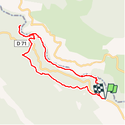
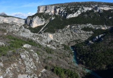
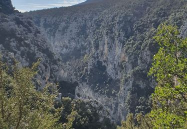
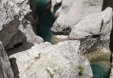
Trail Walking of 9.3 km to be discovered at Provence-Alpes-Côte d'Azur, Var, Aiguines. This trail is proposed by MarcLEBARON.

Description

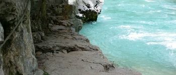
Boucle à partir du Belvédère.
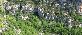
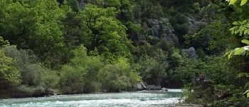
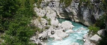
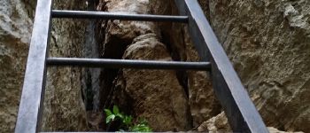
Parcours aérien avec des passages équipés dans les gorges et lors de la remontée par le sentier Vidal.
Pas de difficultés majeures dès l'instant ou l'on est pas sujet au vertige et autres sentiers escarpés au bord de l'eau avec les pierres usées par le passage.

Elevation profile

Photos

Points of interest

Point of interest Aiguines - Point 1 - Photo
MarcLEBARON
AIGUINES 
Point of interest Aiguines - Point 2 - Photo
MarcLEBARON
AIGUINES 
Point of interest La Palud-sur-Verdon - Point 3 - Photo
MarcLEBARON
LA PALUD-SUR-VERDON 
Point of interest Aiguines - Point 8 - Photo
MarcLEBARON
AIGUINES 
Point of interest La Palud-sur-Verdon - Point 9 - Photo
MarcLEBARON
LA PALUD-SUR-VERDON 
Point of interest Aiguines - Point 11 - Photo
MarcLEBARON
AIGUINES 
Point of interest Aiguines - Point 12 - Photo
MarcLEBARON
AIGUINES 
Point of interest Aiguines - Point 10 - Photo
MarcLEBARON
AIGUINES 

Positioning

Country:
France
Region :
Provence-Alpes-Côte d'Azur
Department/Province :
Var
Municipality :
Aiguines
Location:
Unknown
Start:(UTM)
286322 ; 4846086 (32T) N.

Comments

Please log in to post a review or rate the element


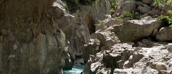
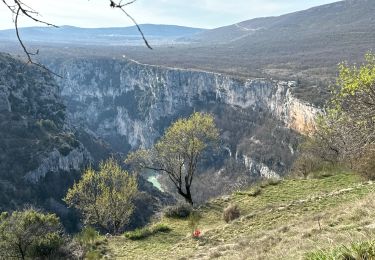
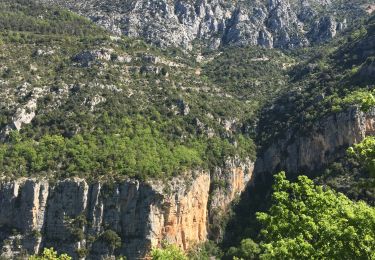
superbe ballade même si épuisante. En cas de grande affluence il serait recommandé de porter un casque lors de la remontée. Le terrain est très friable, il est difficile de ne jamais faire rouler quelques pierre


Probablement le plus extraordinaire des parcours des gorges du Verdon. Je ne mets toutefois que 4 car il est dommage de ne pas inclure le Baou Béni qui bien que plus technique que le sentier Vidal n'en demeure pas moins facile d'accès.Randonnée pour les amateurs de sensations fortes au pied sûr!


Trails nearby

Trail Walking La Palud-sur-Verdon - Sentier Blanc-Martel - Photo
Walking
i20

Walking

Medium
(2)
La Palud-sur-Verdon, Provence-Alpes-Côte d'Azur, Alpes-de-Haute-Provence, France
15.4 km | 31 km-effort
Unknown
No
Trail Walking La Palud-sur-Verdon - Verdon : Sentier Blanc Martel - Photo
Walking
manumax

Walking

Medium
(1)
La Palud-sur-Verdon, Provence-Alpes-Côte d'Azur, Alpes-de-Haute-Provence, France
16.1 km | 39 km-effort
6h 43min
No
Trail Walking La Palud-sur-Verdon - bastidon - Photo
Walking
xav34830

Walking

Medium
(1)
La Palud-sur-Verdon, Provence-Alpes-Côte d'Azur, Alpes-de-Haute-Provence, France
18.4 km | 33 km-effort
Unknown
Yes
Trail Walking La Palud-sur-Verdon - Chalet de la Maline - Point Sublime - Photo
Walking
LtZIP

Walking

Very difficult
La Palud-sur-Verdon, Provence-Alpes-Côte d'Azur, Alpes-de-Haute-Provence, France
14.4 km | 28 km-effort
6h 19min
No
Trail Walking La Palud-sur-Verdon - Sentier Blanc Martel - Photo
Walking
ETMU5496

Walking

Difficult
La Palud-sur-Verdon, Provence-Alpes-Côte d'Azur, Alpes-de-Haute-Provence, France
15.6 km | 31 km-effort
6h 57min
No
Trail Walking La Palud-sur-Verdon - 2023-03-24 Bastidon - Ravin du Brusc - Photo
Walking
GUIDE
Kargil

Walking

Difficult
La Palud-sur-Verdon, Provence-Alpes-Côte d'Azur, Alpes-de-Haute-Provence, France
13.3 km | 25 km-effort
5h 19min
No
Trail Walking Aiguines - Sentier de l'imbut - Photo
Walking
Indi34

Walking

Medium
Aiguines, Provence-Alpes-Côte d'Azur, Var, France
10.4 km | 27 km-effort
4h 0min
Yes
Trail Walking Aiguines - Gorges du Verdon - Sentier de l'Imbut - Photo
Walking
PiloudeBamako

Walking

Very difficult
Aiguines, Provence-Alpes-Côte d'Azur, Var, France
11.3 km | 33 km-effort
3h 35min
No
Trail Walking La Palud-sur-Verdon - Verdon, le sentier Martel - Photo
Walking
liocol

Walking

Difficult
La Palud-sur-Verdon, Provence-Alpes-Côte d'Azur, Alpes-de-Haute-Provence, France
13.2 km | 26 km-effort
5h 24min
No


Close
My subscriptions