


activity_7080920719

topolino
User
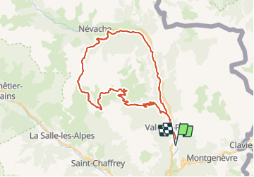

Length
39 km

Max alt
2498 m

Uphill gradient
1288 m
Km-Effort
56 km

Min alt
1376 m

Downhill gradient
1289 m
Boucle
Yes
Creation date :
2021-07-06 18:31:13.664
Updated on :
2021-07-06 18:35:25.881
--
Difficulty : Unknown

FREE GPS app for hiking
 SityTrail
IGN / Geographical institutes
SityTrail Plus
The world is yours!
About
Trail Mountain bike of 39 km to be discovered at Provence-Alpes-Côte d'Azur, Hautes-Alpes, Val-des-Prés. This trail is proposed by topolino.
Positioning
Country:
France
Region :
Provence-Alpes-Côte d'Azur
Department/Province :
Hautes-Alpes
Municipality :
Val-des-Prés
Location:
Unknown
Start:(Dec)
Start:(UTM)
317231 ; 4978688 (32T) N.
Comments