


cèpe

lablaquiere
User
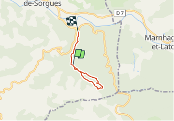

Length
3.9 km

Max alt
565 m

Uphill gradient
89 m
Km-Effort
5.3 km

Min alt
414 m

Downhill gradient
151 m
Boucle
No
Creation date :
2021-07-06 18:04:54.024
Updated on :
2021-07-06 19:32:03.827
1h26
Difficulty : Easy

FREE GPS app for hiking
 SityTrail
IGN / Geographical institutes
SityTrail Plus
The world is yours!
About
Trail Walking of 3.9 km to be discovered at Occitania, Aveyron, Saint-Félix-de-Sorgues. This trail is proposed by lablaquiere.
Positioning
Country:
France
Region :
Occitania
Department/Province :
Aveyron
Municipality :
Saint-Félix-de-Sorgues
Location:
Unknown
Start:(Dec)
Start:(UTM)
499594 ; 4857105 (31T) N.
Comments