


les crêtes de haute meurthe

olivier78000
User
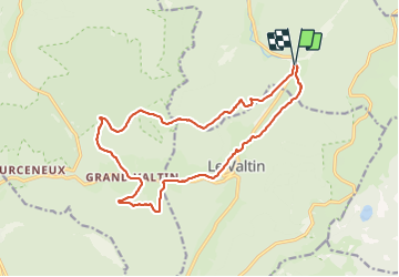

Length
16.2 km

Max alt
1127 m

Uphill gradient
624 m
Km-Effort
25 km

Min alt
699 m

Downhill gradient
627 m
Boucle
Yes
Creation date :
2021-07-07 08:31:31.099
Updated on :
2021-07-08 06:22:25.401
5h32
Difficulty : Medium

FREE GPS app for hiking
 SityTrail
IGN / Geographical institutes
SityTrail Plus
The world is yours!
About
Trail Walking of 16.2 km to be discovered at Grand Est, Vosges, Plainfaing. This trail is proposed by olivier78000.
Positioning
Country:
France
Region :
Grand Est
Department/Province :
Vosges
Municipality :
Plainfaing
Location:
Unknown
Start:(Dec)
Start:(UTM)
354273 ; 5331427 (32U) N.
Comments