


Saint-Étienne-de-Chigny - Pont de Bresme - 23.4km 275m 4h45 (25mn) - 2021 07 08

Orcal37
User GUIDE
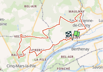

Length
23 km

Max alt
102 m

Uphill gradient
275 m
Km-Effort
27 km

Min alt
44 m

Downhill gradient
275 m
Boucle
Yes
Creation date :
2021-07-08 09:46:17.234
Updated on :
2021-07-08 17:23:18.244
4h45
Difficulty : Easy

FREE GPS app for hiking
 SityTrail
IGN / Geographical institutes
SityTrail Plus
The world is yours!
About
Trail Walking of 23 km to be discovered at Centre-Loire Valley, Indre-et-Loire, Saint-Étienne-de-Chigny. This trail is proposed by Orcal37.
Description
Saint-Étienne-de-Chigny - Pont de Bresme - 23.4km 275m 4h45 (25mn) - 2021 07 08
Photos
 - 2021 07 08 - Photo 1")
 - 2021 07 08 - Photo 2")
 - 2021 07 08 - Photo 3")
 - 2021 07 08 - Photo 4")
 - 2021 07 08 - Photo 5")
Positioning
Country:
France
Region :
Centre-Loire Valley
Department/Province :
Indre-et-Loire
Municipality :
Saint-Étienne-de-Chigny
Location:
Unknown
Start:(Dec)
Start:(UTM)
312460 ; 5249174 (31T) N.
Comments