


fontaines 2

ppn
User
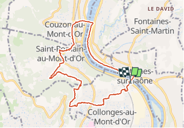

Length
10 km

Max alt
366 m

Uphill gradient
223 m
Km-Effort
13 km

Min alt
165 m

Downhill gradient
223 m
Boucle
Yes
Creation date :
2021-07-09 06:44:09.565
Updated on :
2021-07-09 09:28:53.207
2h43
Difficulty : Difficult

FREE GPS app for hiking
 SityTrail
IGN / Geographical institutes
SityTrail Plus
The world is yours!
About
Trail Walking of 10 km to be discovered at Auvergne-Rhône-Alpes, Métropole de Lyon, Collonges-au-Mont-d'Or. This trail is proposed by ppn.
Positioning
Country:
France
Region :
Auvergne-Rhône-Alpes
Department/Province :
Métropole de Lyon
Municipality :
Collonges-au-Mont-d'Or
Location:
Unknown
Start:(Dec)
Start:(UTM)
643449 ; 5076899 (31T) N.
Comments