


2021-07-10_13h19m40_SityTrail - 2845050 - conliege-trace

robert gallet
User
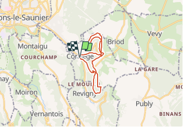

Length
11.7 km

Max alt
557 m

Uphill gradient
516 m
Km-Effort
18.6 km

Min alt
316 m

Downhill gradient
516 m
Boucle
Yes
Creation date :
2021-07-10 11:19:40.074
Updated on :
2021-07-10 11:19:41.691

FREE GPS app for hiking
 SityTrail
IGN / Geographical institutes
SityTrail Plus
The world is yours!
About
Trail of 11.7 km to be discovered at Bourgogne-Franche-Comté, Jura, Conliège. This trail is proposed by robert gallet.
Description
12 km 516 m dénivelé
Positioning
Country:
France
Region :
Bourgogne-Franche-Comté
Department/Province :
Jura
Municipality :
Conliège
Location:
Unknown
Start:(Dec)
Start:(UTM)
698863 ; 5169986 (31T) N.
Comments