


Col du Portet - lac de bastan

mitch1952
User
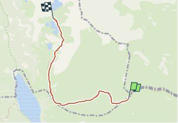

Length
5.4 km

Max alt
2256 m

Uphill gradient
176 m
Km-Effort
7.6 km

Min alt
2104 m

Downhill gradient
144 m
Boucle
No
Creation date :
2021-07-10 13:23:02.244
Updated on :
2022-06-08 14:09:29.542
5h00
Difficulty : Medium

FREE GPS app for hiking
 SityTrail
IGN / Geographical institutes
SityTrail Plus
The world is yours!
About
Trail On foot of 5.4 km to be discovered at Occitania, Hautespyrenees, Saint-Lary-Soulan. This trail is proposed by mitch1952.
Positioning
Country:
France
Region :
Occitania
Department/Province :
Hautespyrenees
Municipality :
Saint-Lary-Soulan
Location:
Unknown
Start:(Dec)
Start:(UTM)
274098 ; 4745975 (31T) N.
Comments