


les rousses le sambrès

Dupleix
User
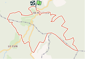

Length
16.4 km

Max alt
959 m

Uphill gradient
457 m
Km-Effort
23 km

Min alt
751 m

Downhill gradient
453 m
Boucle
Yes
Creation date :
2021-07-10 17:07:11.922
Updated on :
2021-07-10 17:10:34.252
5h07
Difficulty : Medium

FREE GPS app for hiking
 SityTrail
IGN / Geographical institutes
SityTrail Plus
The world is yours!
About
Trail On foot of 16.4 km to be discovered at Occitania, Tarn, Mazamet. This trail is proposed by Dupleix.
Description
boucle au depart de l'aire des rousses qui monte en crete de la limite avec l'aude et qui passe e'suite dans les magnfiques bois de gramentès.
Positioning
Country:
France
Region :
Occitania
Department/Province :
Tarn
Municipality :
Mazamet
Location:
Unknown
Start:(Dec)
Start:(UTM)
446324 ; 4810557 (31T) N.
Comments