


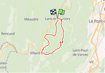
VTT - Lans - Villars

JMHRX2
User

Length
25 km

Max alt
1482 m

Uphill gradient
736 m
Km-Effort
35 km

Min alt
980 m

Downhill gradient
734 m
Boucle
Yes
Creation date :
2021-06-30 09:21:02.444
Updated on :
2021-07-10 17:17:37.734
4h21
Difficulty : Difficult

FREE GPS app for hiking
 SityTrail
IGN / Geographical institutes
SityTrail Plus
The world is yours!
About
Trail Mountain bike of 25 km to be discovered at Auvergne-Rhône-Alpes, Isère, Lans-en-Vercors. This trail is proposed by JMHRX2.
Positioning
Country:
France
Region :
Auvergne-Rhône-Alpes
Department/Province :
Isère
Municipality :
Lans-en-Vercors
Location:
Unknown
Start:(Dec)
Start:(UTM)
703604 ; 5000377 (31T) N.
Comments