


la londe collobriere la londe

belino2
User
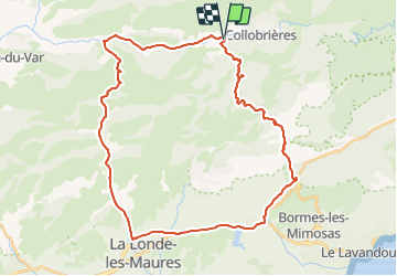

Length
42 km

Max alt
557 m

Uphill gradient
955 m
Km-Effort
55 km

Min alt
20 m

Downhill gradient
957 m
Boucle
Yes
Creation date :
2021-07-11 12:24:52.784
Updated on :
2021-07-11 12:26:15.342
--
Difficulty : Very easy

FREE GPS app for hiking
 SityTrail
IGN / Geographical institutes
SityTrail Plus
The world is yours!
About
Trail Cycle of 42 km to be discovered at Provence-Alpes-Côte d'Azur, Var, Collobrières. This trail is proposed by belino2.
Description
41.5kms
Positioning
Country:
France
Region :
Provence-Alpes-Côte d'Azur
Department/Province :
Var
Municipality :
Collobrières
Location:
Unknown
Start:(Dec)
Start:(UTM)
279683 ; 4790564 (32T) N.
Comments