


Belgentier 12 juillet 2021

rlebasque
User
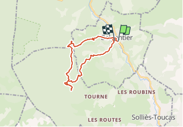

Length
14.1 km

Max alt
621 m

Uphill gradient
570 m
Km-Effort
22 km

Min alt
150 m

Downhill gradient
571 m
Boucle
Yes
Creation date :
2021-07-12 06:02:00.929
Updated on :
2021-07-12 10:39:24.494
4h34
Difficulty : Very difficult

FREE GPS app for hiking
 SityTrail
IGN / Geographical institutes
SityTrail Plus
The world is yours!
About
Trail Walking of 14.1 km to be discovered at Provence-Alpes-Côte d'Azur, Var, Belgentier. This trail is proposed by rlebasque.
Positioning
Country:
France
Region :
Provence-Alpes-Côte d'Azur
Department/Province :
Var
Municipality :
Belgentier
Location:
Unknown
Start:(Dec)
Start:(UTM)
256530 ; 4792199 (32T) N.
Comments