


peyrouse

ascq
User
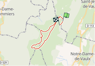

Length
6.3 km

Max alt
1707 m

Uphill gradient
247 m
Km-Effort
9.7 km

Min alt
1465 m

Downhill gradient
279 m
Boucle
No
Creation date :
2021-07-12 09:18:09.853
Updated on :
2021-07-12 12:03:41.489
2h45
Difficulty : Medium

FREE GPS app for hiking
 SityTrail
IGN / Geographical institutes
SityTrail Plus
The world is yours!
About
Trail Walking of 6.3 km to be discovered at Auvergne-Rhône-Alpes, Isère, Saint-Jean-de-Vaulx. This trail is proposed by ascq.
Positioning
Country:
France
Region :
Auvergne-Rhône-Alpes
Department/Province :
Isère
Municipality :
Saint-Jean-de-Vaulx
Location:
Unknown
Start:(Dec)
Start:(UTM)
715960 ; 4987114 (31T) N.
Comments