


AURIS 10KM

jpb83
User
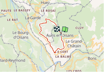

Length
10.8 km

Max alt
1702 m

Uphill gradient
674 m
Km-Effort
19.7 km

Min alt
1185 m

Downhill gradient
671 m
Boucle
Yes
Creation date :
2021-07-12 17:09:32.755
Updated on :
2021-07-12 17:09:35.646
3h29
Difficulty : Easy

FREE GPS app for hiking
 SityTrail
IGN / Geographical institutes
SityTrail Plus
The world is yours!
About
Trail Walking of 10.8 km to be discovered at Auvergne-Rhône-Alpes, Isère, Auris. This trail is proposed by jpb83.
Positioning
Country:
France
Region :
Auvergne-Rhône-Alpes
Department/Province :
Isère
Municipality :
Auris
Location:
Unknown
Start:(Dec)
Start:(UTM)
269957 ; 4993103 (32T) N.
Comments