


Cagire-terrain et WP-Visu-TC-AC

mitch1952
User
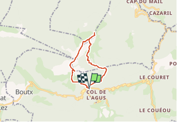

Length
10.5 km

Max alt
1899 m

Uphill gradient
793 m
Km-Effort
21 km

Min alt
1289 m

Downhill gradient
791 m
Boucle
Yes
Creation date :
2021-07-13 07:03:57.689
Updated on :
2022-06-08 14:10:52.035
4h46
Difficulty : Very difficult

FREE GPS app for hiking
 SityTrail
IGN / Geographical institutes
SityTrail Plus
The world is yours!
About
Trail Walking of 10.5 km to be discovered at Occitania, Haute-Garonne, Boutx. This trail is proposed by mitch1952.
Points of interest


Positioning
Country:
France
Region :
Occitania
Department/Province :
Haute-Garonne
Municipality :
Boutx
Location:
Unknown
Start:(Dec)
Start:(UTM)
317338 ; 4754250 (31T) N.
Comments