


2021-07-13_10h21m50_10212002

dejongm
User
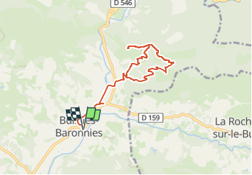

Length
8.4 km

Max alt
743 m

Uphill gradient
437 m
Km-Effort
14.3 km

Min alt
372 m

Downhill gradient
437 m
Boucle
Yes
Creation date :
2021-07-13 08:21:50.886
Updated on :
2024-08-06 07:26:19.526
3h14
Difficulty : Difficult

FREE GPS app for hiking
 SityTrail
IGN / Geographical institutes
SityTrail Plus
The world is yours!
About
Trail Walking of 8.4 km to be discovered at Auvergne-Rhône-Alpes, Drôme, Buis-les-Baronnies. This trail is proposed by dejongm.
Description
Parcourez ce circuit jalonné de panneaux d'interprétation autour du Rocher de l'Aiguille. Il serpente dans un écrin sauvage parsemé d'une flore représentative des Baronnies provençales.
Positioning
Country:
France
Region :
Auvergne-Rhône-Alpes
Department/Province :
Drôme
Municipality :
Buis-les-Baronnies
Location:
Unknown
Start:(Dec)
Start:(UTM)
681625 ; 4905063 (31T) N.
Comments