le Lioran -Plomb du cantal via le puy du Rocher

mrcat
User
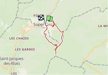

Length
10.7 km

Max alt
1839 m

Uphill gradient
662 m
Km-Effort
19.5 km

Min alt
1241 m

Downhill gradient
659 m
Boucle
Yes
Creation date :
2021-07-14 12:48:52.165
Updated on :
2021-07-14 16:14:37.367
3h25
Difficulty : Very difficult

FREE GPS app for hiking
 SityTrail
IGN / Geographical institutes
SityTrail Plus
The world is yours!
About
Trail Walking of 10.7 km to be discovered at Auvergne-Rhône-Alpes, Cantal, Laveissière. This trail is proposed by mrcat.
Positioning
Country:
France
Region :
Auvergne-Rhône-Alpes
Department/Province :
Cantal
Municipality :
Laveissière
Location:
Unknown
Start:(Dec)
Start:(UTM)
480289 ; 4992104 (31T) N.
Comments