


forêt de Crannou 15-07-2021

jmrobin
User
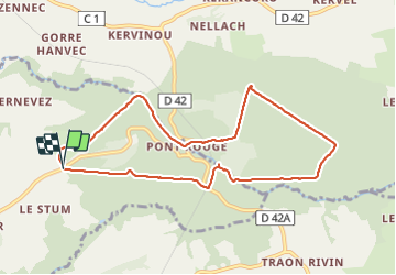

Length
8.5 km

Max alt
191 m

Uphill gradient
172 m
Km-Effort
10.8 km

Min alt
86 m

Downhill gradient
176 m
Boucle
Yes
Creation date :
2021-07-15 12:32:00.786
Updated on :
2021-07-15 14:51:03.196
2h18
Difficulty : Medium

FREE GPS app for hiking
 SityTrail
IGN / Geographical institutes
SityTrail Plus
The world is yours!
About
Trail Walking of 8.5 km to be discovered at Brittany, Finistère, Le Faou. This trail is proposed by jmrobin.
Positioning
Country:
France
Region :
Brittany
Department/Province :
Finistère
Municipality :
Le Faou
Location:
Unknown
Start:(Dec)
Start:(UTM)
416900 ; 5351700 (30U) N.
Comments