


Le Landin-Forêt de Brotonne

JMCMoreau
User
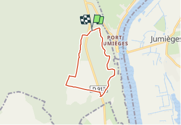

Length
5.2 km

Max alt
149 m

Uphill gradient
95 m
Km-Effort
6.5 km

Min alt
97 m

Downhill gradient
91 m
Boucle
Yes
Creation date :
2021-07-16 08:44:29.596
Updated on :
2021-07-16 08:46:27.562
2h00
Difficulty : Very easy

FREE GPS app for hiking
 SityTrail
IGN / Geographical institutes
SityTrail Plus
The world is yours!
About
Trail Walking of 5.2 km to be discovered at Normandy, Seine-Maritime, Arelaune-en-Seine. This trail is proposed by JMCMoreau.
Description
Un parcours pour les Bibous
Positioning
Country:
France
Region :
Normandy
Department/Province :
Seine-Maritime
Municipality :
Arelaune-en-Seine
Location:
La Mailleraye-sur-Seine
Start:(Dec)
Start:(UTM)
339911 ; 5477992 (31U) N.
Comments