Roppeviller

philvor
User
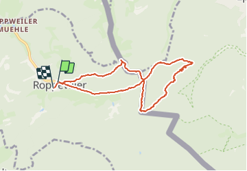

Length
8.3 km

Max alt
408 m

Uphill gradient
188 m
Km-Effort
10.8 km

Min alt
290 m

Downhill gradient
196 m
Boucle
Yes
Creation date :
2021-07-16 08:24:40.988
Updated on :
2021-07-16 12:28:45.001
4h00
Difficulty : Medium

FREE GPS app for hiking
 SityTrail
IGN / Geographical institutes
SityTrail Plus
The world is yours!
About
Trail Walking of 8.3 km to be discovered at Grand Est, Moselle, Roppeviller. This trail is proposed by philvor.
Description
le Colorado du Bitcherland
Positioning
Country:
France
Region :
Grand Est
Department/Province :
Moselle
Municipality :
Roppeviller
Location:
Unknown
Start:(Dec)
Start:(UTM)
391098 ; 5439861 (32U) N.
Comments