


Rigny-Ussé - Bréhémont - 25.7km 110m 5h30 (40mn) - 2021 07 17

Orcal37
User GUIDE
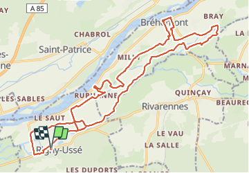

Length
26 km

Max alt
47 m

Uphill gradient
109 m
Km-Effort
27 km

Min alt
32 m

Downhill gradient
111 m
Boucle
Yes
Creation date :
2021-07-17 09:31:20.062
Updated on :
2021-07-17 18:40:57.832
5h30
Difficulty : Easy

FREE GPS app for hiking
 SityTrail
IGN / Geographical institutes
SityTrail Plus
The world is yours!
About
Trail Walking of 26 km to be discovered at Centre-Loire Valley, Indre-et-Loire, Rigny-Ussé. This trail is proposed by Orcal37.
Description
Rigny-Ussé (PR) - liaison avec PR de Bréhémont (PR) - 25.7km 110m 5h30 (40mn) - 2021 07 17
Photos
 - 2021 07 17 - Photo 1")
 - 2021 07 17 - Photo 2")
 - 2021 07 17 - Photo 3")
 - 2021 07 17 - Photo 4")
 - 2021 07 17 - Photo 5")
 - 2021 07 17 - Photo 6")
 - 2021 07 17 - Photo 7")
 - 2021 07 17 - Photo 8")
 - 2021 07 17 - Photo 9")
 - 2021 07 17 - Photo 10")
Positioning
Country:
France
Region :
Centre-Loire Valley
Department/Province :
Indre-et-Loire
Municipality :
Rigny-Ussé
Location:
Unknown
Start:(Dec)
Start:(UTM)
295649 ; 5236808 (31T) N.
Comments