


SityTrail - Col Supeyres-StGeorges- Tronçon 2

ophness
User
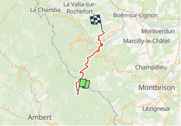

Length
24 km

Max alt
1433 m

Uphill gradient
558 m
Km-Effort
33 km

Min alt
667 m

Downhill gradient
1081 m
Boucle
No
Creation date :
2021-07-18 09:32:04.324
Updated on :
2021-07-18 09:32:27.808
4h23
Difficulty : Difficult

FREE GPS app for hiking
 SityTrail
IGN / Geographical institutes
SityTrail Plus
The world is yours!
About
Trail Horseback riding of 24 km to be discovered at Auvergne-Rhône-Alpes, Puy-de-Dôme, Valcivières. This trail is proposed by ophness.
Positioning
Country:
France
Region :
Auvergne-Rhône-Alpes
Department/Province :
Puy-de-Dôme
Municipality :
Valcivières
Location:
Unknown
Start:(Dec)
Start:(UTM)
565973 ; 5049131 (31T) N.
Comments