


bost bof

bendoush
User

Length
13.5 km

Max alt
481 m

Uphill gradient
294 m
Km-Effort
17.4 km

Min alt
269 m

Downhill gradient
293 m
Boucle
Yes
Creation date :
2021-07-18 10:34:58.012
Updated on :
2021-07-18 14:19:05.697
3h43
Difficulty : Medium

FREE GPS app for hiking
 SityTrail
IGN / Geographical institutes
SityTrail Plus
The world is yours!
About
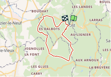
Trail Walking of 13.5 km to be discovered at Auvergne-Rhône-Alpes, Allier, Bost. This trail is proposed by bendoush.
Photos


Positioning
Country:
France
Region :
Auvergne-Rhône-Alpes
Department/Province :
Allier
Municipality :
Bost
Location:
Unknown
Start:(Dec)
Start:(UTM)
539968 ; 5114046 (31T) N.
Comments