


Plateau du Lisey avec Sabine

mitch1952
User
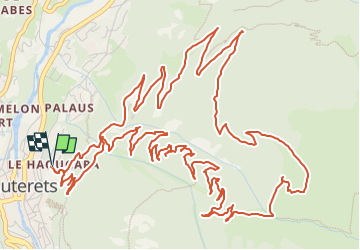

Length
11.9 km

Max alt
1646 m

Uphill gradient
708 m
Km-Effort
21 km

Min alt
950 m

Downhill gradient
711 m
Boucle
Yes
Creation date :
2021-07-18 16:18:25.188
Updated on :
2022-06-08 14:11:52.175
4h51
Difficulty : Medium

FREE GPS app for hiking
 SityTrail
IGN / Geographical institutes
SityTrail Plus
The world is yours!
About
Trail On foot of 11.9 km to be discovered at Occitania, Hautespyrenees, Cauterets. This trail is proposed by mitch1952.
Description
Randonnée réalisée le 18 juillet 2021 avec Sabine , très beau temps , trace corrigée avec Waypoints incorporés .
A noter 21 virages numérotés.
Réglage du GPS à 20 secondes entre chaque point .
Points of interest


Positioning
Country:
France
Region :
Occitania
Department/Province :
Hautespyrenees
Municipality :
Cauterets
Location:
Unknown
Start:(Dec)
Start:(UTM)
735858 ; 4752710 (30T) N.
Comments